Resource Management and Litigation Support
 Restoration Progress Assessments
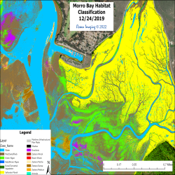
For over 20 years Ocean imaging has been involved in the long-term monitoring of several wetland restoration efforts. Our initial work involved the delineation of native and invasive species and percent bare soil coverage. The data we now use are very high resolution (as detailed as a few centimeters) multispectral imagery acquired from aircraft, UAS or satellite sensors depending on the application. The data and resulting habitat/substrate/vegetation analyses are used to plan and monitor restoration activities which includes regularly monitoring the progress of the revegetation of newly planted areas. One example of this is the work we have been doing for the California Coastal Commission for the past fifteen years to map and monitor the restoration of the San Dieguito Lagoon in San Diego, California.
 Expert Witness Testimony
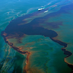
Our staff has served as Expert Witness (both plaintiff and defendant) in cases involving oil spills, sewage discharge and water quality changes. In some cases, we used our own aerial instruments to acquire data for analysis and testimony. We have also provided data and analyses to aid environmental damage-related settlements.
 Natural Resource Surveys
Ocean Imaging’s aerial multispectral imaging is being used by state and federal agencies to provide assessments of managed resources such as kelp beds and eel grass distributions. We are also involved in the establishment of baseline natural resource data bases related to the creation of coastal Marine Protected Areas (MPAs).
 Water Quality and Runoff Monitoring
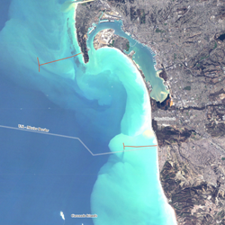
Ocean Imaging pioneered the use of satellite and aerial imagery for monitoring wastewater outfalls with NASA research funds in the 90s. Since then, OI has been monitoring several outfalls as part of regional water quality monitoring programs mandated by their discharge permits. Our technology helped separate the potential effects of the outfall plumes from other sources of polluted runoff nearby and even aided in the settlement of lawsuits related to one of the outfalls. Our image analyses are done in conjunction with traditional field sampling and help interpret the field as well as interpolate them in time and space. The image to the shows the coastal region of San Diego as seen from the Rapid Eye satellite. In 2002 Ocean Imaging Corp. initiated a project to utilize satellite and aerial remote sensing technology for monitoring wastewater plumes and stormwater runoff in the San Diego area. The work is collectively funded by the California State Water Resources Control Board, the City of San Diego and the International Boundary Waters Commission. The project uses data from several satellite sensors including MODIS, TM, ETM, RapidEye, Sentinel 2A & 2B, VIIRS, IRS and ERS-II to help these agencies monitor discharge from the local water treatment plants.
Services and Capabilities
Fisheries Support Services
Natural Resource Mapping and Monitoring
Oil Spill Response and Research
Geospatial Environmental Analysis
Resource Management and
Litigation Support >>
