Fisheries Support Services
SeaView Fishing Service & Software
Since 1983 Ocean Imaging's worldwide fish finding services have provided customers with ready-to-use analysis products, saving them fuel, time and money while helping better manage their operation. Our time-tested SeaView Sport© and SeaView Pro© Commercial services bring state-of-the-art oceanographic and weather data straight to your home, office or boat PC. This affordable service is now used with great success by fishing fleets and scientists worldwide.
To find fish from space we utilize only the most sophisticated and high-resolution satellite data which are processed minutes after acquisition. Our powerful SeaView© software then lets you combine the very latest oceanographic data such as SST, plankton levels, salinity, mixed layer depth, ocean currents, sea surface height, ocean currents and weather information with your fishing expertise to make better decisions while at sea. We also offer high-quality data composite, model-derived data and cloud-free imagery to virtually eliminate the problem of cloud cover.
Our vast fisheries support expertise, timely, pinpoint accuracy image products and SeaView© make us the leader in fisheries support world-wide. No other service offers the variety of oceanographic data products, updated up to 4-16 times per day and the functionality of SeaView© - all for a very affordable price! Whether you are a serious recreational angler looking for the best environmental information, or a commercial fishing operation in need of a reliable, accurate oceanographic tool-kit, Ocean Imaging's fishing support services are the right choice.
Fisheries Research
From its very beginning Dr. Svejkovsky and Ocean Imaging realized the value of fisheries research to help promote the understanding and longevity of this valuable world resource. OI has been involved in many fishery-related research projects funded by such organizations as the National Marine Fisheries Service, American Fishermen's Research Foundation, the Arctic-Yukon-Kuskokwim Sustainable Salmon Initiative (AYK SSI), Omega Protein, Sea Grant, and the County of Santa Barbara Fisheries Enhancement Fund. We have studied how the distribution patterns of albacore tuna relate to three-dimensional physical ocean structure in the North Pacific Ocean; how oceanic frontal zones and meso-scale circulation as seen in sea surface height anomaly data affect the movement and distribution of albacore tuna; how real time satellite derived sea surface temperature (SST) and ocean turbidity products can provide plant managers, boat captains and spotter pilots a better understanding of the environmental influences on menhaden distribution and behavior; how the development and distribution of a Satellite-derived Multivariate oceanographic database can help evaluate the potential impact/importance of the remotely sensed variables on salmon declines in the Arctic-Yukon-Kuskokwim region of the Bearing Sea (and to help guide future research priorities).

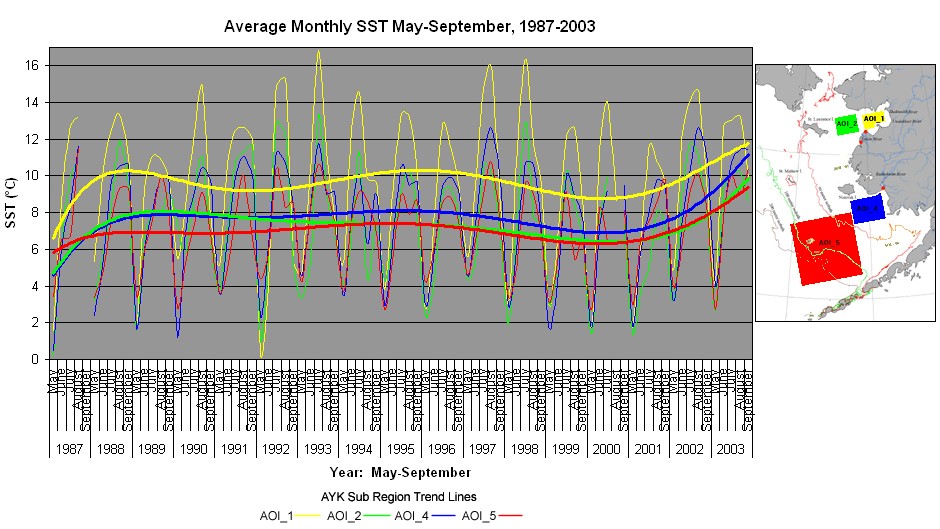
Average AVHRR-derived, monthly SST values in the Bering Sea for May-September 1987-2003. Mean SSTs for the sub-regions AOI_1, AOI_2, AOI_4 and AOI_5 are shown. The thick lines show the sixth order curvilinear trend lines. Satellite-derived data such as these acquired over a 16-year period were used to help determine whether environmental variations in the Bering Sea over a 20-year period played a role in the devastating drop in salmon stocks along its Alaskan shores which took place in the late 1990s and early 2000s.
Ocean Imaging continues to place an emphasis on oceanographic and fisheries research as part of our company's efforts to be good stewards of the sea.

